Boston Harbor
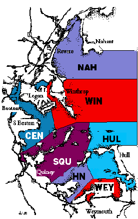
Winter TASL census regions
These divisions of the Harbor were established in 1980 and the route used for each census region has been roughly the same over the years. Currently 11 parties cover the seven regions. Each census lasts approximately three to four hours.
In order to achieve maximum reliability in counts we have tried to keep the same censusers working the same routes over the years. We also try to schedule the censuses to coincide with rising or high tides.
Harbor map by Julie Roberts
TASL census routes
NAH—Nahant / Revere
Lynn Harbor.htm [95 Kb]
Lynn Harbor.pdf [191 Kb]
Lynn Harbor.doc [99 Kb]
WIN—Winthrop
Broad Sound.htm [85 Kb]
Broad Sound.pdf [152 Kb]
Broad Sound.doc [98 Kb]
Deer Island.doc [97 Kb]
Winthrop Harbor.doc [99 Kb]
CEN—East Boston to Neponset
East Boston to South Boston.htm [150 Kb]
East Boston to South Boston.pdf [151 Kb]
East Boston to South Boston.doc [103 Kb]
Neponset to L St Beach.htm [135 Kb]
Neponset to L St Beach.doc [97 Kb]
SQU—Squantum / Wollaston / Long Island
Squantum.doc [99 Kb]
HN—Hough's Neck / Nut Island
Hough's Neck.doc [99 Kb]
WEY—Weymouth
Weymouth.doc [99 Kb]
HUL—Hull
Hull.doc [101 Kb]

last updated: 2014.07.01
url: http://032acf2.netsolhost.com/taslroutes.htm
| 
