|
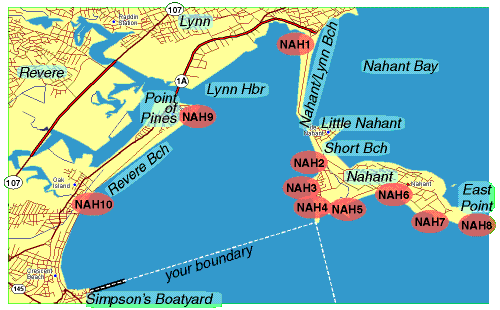
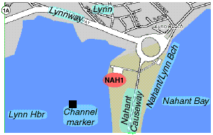
NAH1: Lynnway Rotary—From rotary at N end of Nahant Causeway go south 200 yards toward Nahant, take first right into public landing parking lot. Everything visible in Lynn Harbor is countable. Pay particular attention to shorebirds on channel-marker rockpile to SW.
|
|
|
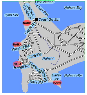
NAH2: Coast Guard Station—Go S on Nahant Causeway past Little Nahant. Take first right on Castle Road. Park behind drugstore on left. Walk across street and census everything in Lynn Harbor to NW.
NAH3: Black Rock Point—Continue SW on Castle Road, take first right on Wendell Road. Check birds W toward Point of Pines, SW along beach.
NAH4: West Cliff—Go back to Castle Road and go right. At fifth right take Range Road to parking lot of VFW Club. Census W and S along beach.
NAH5: Bailey Hill—Back on Castle Road, continue SE to Colby Way. At end take left on Bass Road, park at Bailey Park. Walk up hill next to sea cliffs and check entire perimeter of park. Look S toward Hull, then E and NE into Nahant Harbor.
|
|
|
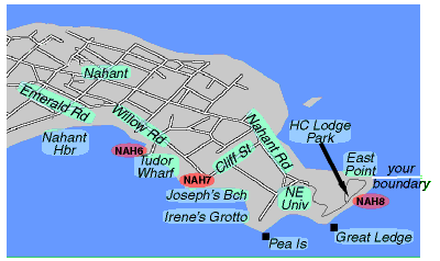
NAH6: Tudor Wharf—Retrace route to intersection of Castle Road with Flash Road. Take a right on Flash Road and follow to right on Emerald Road, then left on Willow Road. Take a right on Wharf Street and park at end of wharf. Census birds in cove E of wharf.
NAH7: Joseph's Beach—Return to Willow Road, take a right and go to end. After taking a left on Cliff Street, park on right and census Joseph's Beach Cove and Irene's Grotto.
NAH8: East Point-—Continue on Cliff Street to end. Take a right on Nahant Road and follow to parking lot at end next to Northeastern University fence and gate.
Note: You need a Nahant Resident Parking Sticker to park here for East Point.
Walk through gates and follow painted lines on road to Henry Cabot Lodge Park at top of hill. Census birds in open ocean south of East Point.
When returning to cars, at sharp turn in road where Boston skyline is visible in distance, check ledges and Pea Island carefully: Harlequin and Lesser Black-backed Gull have been seen on these ledges.
|
|
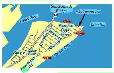
| NAH9: Point of Pines—From Lynnway Rotary go SW across General Edwards Bridge. Follow exit signs for Point of Pines; after going under the overpass, turn left, then bear right to avoid recrossing GE Bridge. Take a right on Rice Avenue.
NAH9a—Park shortly after Point of Pines Yacht Club. Walk across street and up berm to see mouth of Pines River and beach. Check gulls here carefully.
NAH9b—Continue on Rice Avenue. Take a right at Wadsworth Avenue. Park near end. Walk to beach. Check rack line for roosting shorebirds at higher tides.
NAH9c—Take a right at Rice Avenue, a right at Bickford Street, then a left at end on Lynnway. Continue to rotary at Carey Circle (NE end of Revere Beach Road).
Lump all counts from 9a, 9b and 9c.
|
|
|
NAH10: Revere Beach—Continue SW on Revere Beach Road.
NAH10a—Stop ¼-mile from Carey Circle. Check for gulls, shorebirds and ducks.
NAH10b—Continue SW to Oak Island Road (first right). Check for gulls, shorebirds and ducks.
NAH10c—Continue SW to Hartford Street (Revere Beach Road becomes one-way the wrong way here.) Go right, then immediately left on Ocean Avenue. Continue S to Eliot Circle (rotary at SW end of Revere Beach). Check for gulls, shorebirds, ducks and cormorants.
Lump all counts from 10a, 10b and 10c.
Note: Your boundary-line runs almost directly E from the rotary. |

|
